At first glance, it might seem the proximity of the northern emirates to Iran's Zagros fault line - the meeting point for the Arabian and Eurasian tectonic plates - was the sole consideration when burying the final sensor for a global earthquake monitoring system.
But the reason was about geology as much as geography: scientists believed that an outcrop of volcanic rock and ophiolite - slices of the Earth's oceanic crust and upper mantle pushed up on to land tens of millions of years ago - would provide the right stability for recording seismic signals with full fidelity and little distortion.
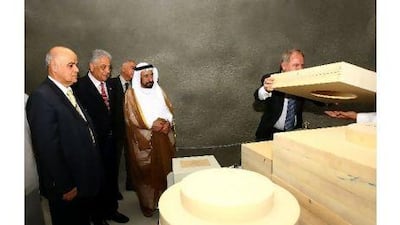
The last of the Global Seismographic Network's 150 monitoring sensors was buried deep in a Sharjah mountain last month, closing a network gap in the region and providing the tools for a multidimensional snapshot of the structure of rocks beneath our feet.
The network is meant to be distributed evenly across the globe for near-uniform monitoring of the Earth.
To create this last sensor station, scientists with the University of Sharjah Seismic Station and the University of California, San Diego carved out tunnels leading to a vaulted tomb 19 metres deep inside Wadi al Helou, where rocks formed from lava and marine sediments are interleaved.
The hard rock is ideal because even slightly loose sediments tend to amplify or distort the signals coming from an earthquake, said Dr Peter Davis, a seismologist from the Institute of Geophysics and Planetary Physics at the San Diego school and one of the project supervisors.
"Similar to an X-ray, our stations are like the photographic plate or detector, and energy from the earth will help us to build up an image of the [Earth's] tissue and to create that photograph," he said.
Because the rocks are so stable, it is easier to gauge how the rocks in the area are absorbing and transmitting energy when an earthquake occurs.
The sensor itself is a cube with sides of 10cm - though the insulation and packaging make the device about three times larger. The delicate measuring tool is protected from changes in temperature or air pressure.
Within the cube is a glass vacuum jar, encasing a pendulum and electric coils to create a current. The coil is attached by wire to a computing device within the sensor that can detect different characteristics, dimensions and speeds of energy waves.
The instrument works in a way similar to a microphone as it detects and records frequencies, but with greater accuracy.
"These are simply microphones that pick up sounds too low in frequency for humans to hear," Dr Davis said.
Information from the sensor is sent through a telephone line to other monitoring stations around the world to create a picture of a particular event. Researchers are able to use the network to determine whether the earthquake's magnitude was strong but distant, or a nearby tremor.
They can also determine the type of seismic wave: a body wave that travels through the earth's interior, or a wave travelling along the surface of the earth.
Primary body waves are the fastest among the different waves generated by earthquakes and travel at the speed of sound. They are the first to be detected by seismic monitoring equipment and can travel through solids and liquids. Secondary body waves, meanwhile, can travel only in solids, such as rocks, but not in liquids.
Researchers look at the difference in arrival times of primary and secondary waves to find the epicentre of an earthquake.
Surface waves, which travel not through the Earth's core but its crust, arrive after body waves and are easily distinguished on a seismogram. The low-frequency surface waves cause the most damage and destruction in earthquakes.
While the UAE has an active fault line near Dibba that has caused tremors in recent years, the country is considered to be in a stable, low-risk seismic area, said Prof Abdullah Shanableh, the project director.
Still, we are not immune. Fujairah was shaken by the moderate 5.1-magnitude Masafi earthquake in 2002, and the northern emirates are close enough to the Arabian and Eurasian tectonic plates that they warrant closer local monitoring, he said. Less than 500km away in Bam, Iran, a 6.6-magnitude earthquake killed 26,271 people in 2003.
The University of Sharjah plans to install two more smaller monitoring centres to get a finer sense of the risks, and to better determine what local seismic building codes should be.
"We just do not currently have all of the [data] we need to know for sure exactly how safe we need to be," Prof Shanableh said.

