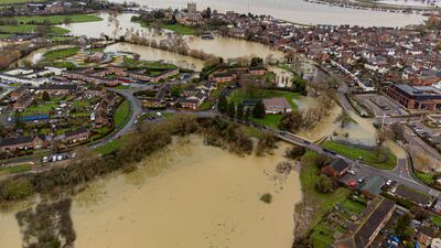
Heavy rain and blustery winds are battering the UK this weekend, with snowy conditions forecast for many parts for next week as temperatures plunge.
The Met Office has issued yellow warnings for rain for Wales and many parts of England, as well as similar warnings for wind and rain in Northern Ireland
Some parts of west and south-west England have already experienced flooding.
Heavy rain in Wales and areas of England including the North East, the North West, the South West, Yorkshire and West Midlands could result in flooding.
Forecasters are warning that bus and train services will probably be affected, while spray and flooding on roads is set to make journey times longer.
A total of 20mm to 30mm of rain is likely quite widely, with 40mm to 50mm expected on some hills.

Flood warnings
The Environment Agency has issued 98 flood warnings across the UK, mostly in the west and the south-west of England, as well as 169 flood alerts.
An alert for severe cold weather from Sunday night has also been issued. The Met Office said there is a 70 per cent chance of snow and ice between Sunday night and Thursday next week, as temperature fall across the UK.
"Showers will be more frequent in western areas and fewer in eastern areas, but becoming increasingly wintry for all areas through Monday," the Met Office said.
"Occasionally strong winds will exacerbate the cold feel. These alerts may be updated on Monday once confidence has improved in the timing of the cold weather and areas to be included."


