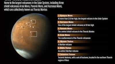
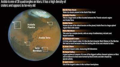
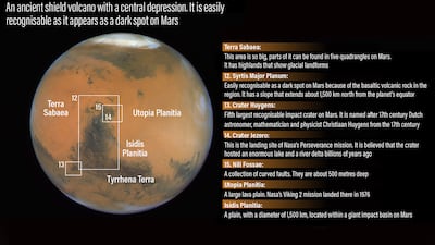
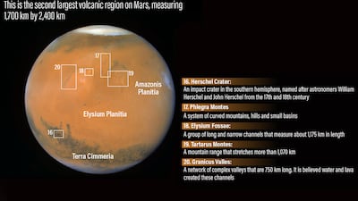
The UAE’s Hope probe tracked a massive dust storm on Mars for more than two weeks, helping to show how quickly they can spread across the planet.
Hope started monitoring a rapidly evolving regional dust storm in late December, as it expanded to a size of several thousand kilometres.
Dust storms on Mars cause extremely turbulent weather. They can be up to 30 kilometres high and cover the entire planet.
The storms can be seen from space, making the planet appear as a bright ball of red.
Scientists hope that by studying them they can gain further insight into how they are drying out the planet by helping Martian water escape the planet's atmosphere.
Hope, which reached orbit in February 2021, used a high-resolution camera and an infrared spectrometer to document the storm’s growth and dissipation.
The instruments revealed the thermal conditions of the planet’s surface and lower atmosphere, giving details about the geographic distribution of dust, water vapour, water and carbon dioxide ice clouds.
Hope’s unique orbital placement has helped to measure these elements over timescales of minutes to days — data that was difficult to capture by all other previous missions because their observations were limited to only certain places and times of day.
Dust storm begins to form
On December 29, Hope captured a fully illuminated disk of Mars, nearly centred on Syrtis Major — a Martian feature that appears as a distinctive dark spot from space and is home to basaltic volcanic rock, stretching about 1,500km north from the planet’s equator.
The atmosphere was relatively clear, with only thin water-ice clouds visible over the plains to the east of Syrtis.
The observations during this time confirmed thick dust clouds only in Hellas, an impact crater in the planet's southern hemisphere, but showed low amounts of suspended dust elsewhere, indicating that a dust storm was forming.
Enormous storm and dust haze
By January 5, the storm had grown massively, stretching 2,500km across, as it approached from the east.
It partially covered Syrtis Major, with greyish water-ice clouds also visible in the storm.
Meanwhile, Hellas was completely covered by dust clouds.
Data from Hope shows that there were high concentrations of dust in Syrtis and Hellas, with haze extending far to the east.
By January 7, dust haze and greyish water-ice clouds spread to the east of Syrtis Major and north of Hellas.
Hope’s data shows that the thickness of the haze increased, lifting the dust from the surface and causing it to extend at least 4,000km east from Syrtis Major.
Starts to dissipate
By January 9, the storm had shrunk in size and moved to north-western Syrtis. It now measured 1,200km across.
The high-resolution camera on the Hope probe was able to capture a fully illuminated hemisphere centred on Syrtis Major again. It had been partially covered by the storm only days earlier.
The dust haze, however, was still covering the plains east of Syrtis, with Hope probe data showing it had spread to span about a third of the circumference of Mars.
The haze started to thin by January 14 and no dust storms were visible by then.


