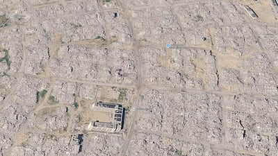
New Google Earth satellite images show vast areas of Gaza transformed by Israel's destructive military offensive, with entire districts reduced to rubble and bare ground.
The updated imagery appeared online on Sunday, according to social media users who expressed shock at the extent of the devastation. Google has not said when the images were published or made available.
The imagery shows neighbourhoods transformed into expanses of rubble from flattened buildings. Roads remain visible, while mosques, schools and other landmarks appear surrounded by extensive destruction.

“This shows the reality of Gaza in shocking resolution,” Nathan Ruser, an analyst at the Australian Strategic Policy Institute, wrote on X.
The southern city of Rafah features prominently in the latest images, with areas that previously featured dense rows of homes now appearing largely cleared. Other views show sprawling concentrations of makeshift shelters across open ground.
In Gaza city, the satellite imagery shows extensive destruction at and around Al Shifa Hospital. The surrounding urban landscape appears significantly altered compared with previous imagery.
'Unfathomable'
The devastation reflects the scale of destruction inflicted during the war in Gaza, which began after the Hamas-led attacks on southern Israel on October 7, 2023.
In a report published on August 12, the UN Satellite Centre said 82 per cent of all Gaza structures had been damaged to some degree, with two thirds of them destroyed.
Barry Andrews, an Irish Member of the European Parliament, highlighted the imagery on X on Sunday. “The updated Google satellite images of Gaza are quite incredible, for all to see,” he wrote. The post was widely shared, with around two million views, 18,000 likes and thousands of reposts.
Other users of the platform reacted with similarly stark descriptions. One post accompanying satellite footage said: “Google Earth updated the images of Gaza. It's devastating.”

Palestinian journalist Abubaker Abed described the imagery as “truly unfathomable”. “I've walked through much of the destruction in Gaza myself, but I couldn't bear looking at the map,” he wrote on X.
The destruction visible in the satellite imagery is the result of nearly three years of war and intense Israeli bombardment and military operations across Gaza since October 7, 2023.
Within hours of the newly published images coming to light, screenshots and videos of Rafah, Khan Younis and Gaza city spread across social media, with users comparing the new views to older satellite imagery.
The precise date on which the images has yet to be established. Reports indicate some high-resolution Gaza imagery has been captured throughout this year but Google has not publicly confirmed the upload date of the latest images.
The Hamas-led October 7 attacks on southern Israel killed about 1,200 people while around 250 hostages were taken, the Israeli authorities say.
Israel responded with a military offensive that Gaza's health authorities say has since killed more than 74,000 Palestinians, with tens of thousands more injured.
Israel has been accused of war crimes over its conduct during the extensive military campaign, including allegations involving attacks on civilians and civilian infrastructure, forced displacement and restrictions on humanitarian aid. Israel denies the allegations.