Solar-powered unmanned boats have become the latest US Navy innovations to set sail in the Middle East.
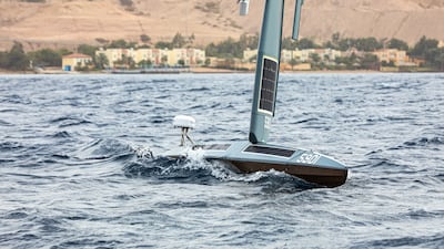
The autonomously navigating vessels, called Saildrones, resemble small amateur sailing boats. The US navy began operating the Saildrone Explorer unmanned vessel in the Arabian Gulf on January 27.
The Saildrone Explorer was originally designed to collect environmental information on the oceans for research, making a 4,100-kilometre crossing from the west coast of the US to Hawaii in 2013.
World's largest drone aircraft - in pictures
That crossing shows the potential of the low-cost vessel: designers claim it can endure 12-month missions in extreme weather, including hurricanes, without any requirement for fuel or new batteries.
The apparent small size of the craft is deceptive. Weighing 14 tonnes, it is equipped with sensors for mapping the ocean floor, using sonar to take snapshots of the sea bed’s bathymetry, or underwater topography.
Saildrone — the company shares its name with the vessel — says the boats can map the bottom of the sea to a depth of 7,000 metres, which could help create models of where tsunamis are likely to cause the most damage, aiding efforts to protect inland areas, as well as estimating the intensity of cyclones as they cross the ocean.
But the boats also have another application: a fleet of them, dispersed over a vast area, could create what US Navy Central Command Commander Michael Brasseur called enhanced “maritime domain awareness".
Last year, Brian Connon, Saildrone’s vice president of ocean mapping, said that drones could help chart a safe course for submarines.
“From a defence perspective, we’re using these to look for seamounts that might be a hazard to submarine navigation,” he said, at a US Navy conference in Maryland.
Underwater mountains dot parts of the ocean floor and many of them have not been adequately mapped. Submarines can use sonar to avoid colliding with the rock formations, but it would risk giving away their position to enemy submarines or ships.
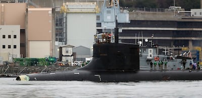
In November last year, a $3 billion Seawolf-class US Navy submarine, the USS Connecticut, suffered severe damage after colliding with an undersea mountain. Eleven sailors were injured and the front of the vessel was partially torn off.

Using sonar, the Saildrones could quickly map terrain to reduce this risk, while potentially providing the capability to detect enemy submarines or similar small craft.
China and Iran have both developed small unmanned surface vessels and small submarines which could pose a threat for much larger US nuclear submarines.
Navcent began military testing of Saildrones in December, with a dedicated technology testing group, Task Force 59, partnering with the Royal Jordanian Navy at a base Aqaba, Jordan.
“The initial Saildrone assessment phase at sea in the Gulf of Aqaba has exceeded our expectations,” said Thomas McAndrew, the task force’s deputy commander. “We are applying the results and rapidly expanding operations.”


